


 Reply With Quote
I've seen rides where riders are asked to submit their data from Polars, GPS units, whatever... I assume the ride organizer looks at all the numbers and makes some determination.
Did you see this for the Hilly Hundred?
http://www.hillyhundred.org/PDF_Files/Hills.pdf
Those aren't hills; most of those are rollers.
Remember max incline could be from one spot on the hill, not the entire hill. It would be like saying our Mount Diablo is a ten mile 18% climb, just because the last tenth of a mile is 18%.
Veronica
Welcome guest, is this your first visit? Click the "Create Account" button now to join.

Results 16 to 30 of 39
Thread: Motion Based Question
-
10-20-2008, 05:14 PM #16
 f/k/a Mr. S.
- Join Date
- Dec 2006
- Location
- Blessed to be all over the place!
- Posts
- 3,433
To disable ads, please log-in.
I'm presuming GeoBike is a different vendor, but it does raise the question of whether we're comparing equally errant sources Originally Posted by OakLeaf

 If you don't grow where you're planted, you'll never BLOOM - Will Rogers
-
10-20-2008, 05:36 PM #17
"Ride lots!"
- Join Date
- Oct 2002
- Location
- San Francisco Bay Area
- Posts
- 9,324
-
10-20-2008, 06:09 PM #18
Inner Geekette
- Join Date
- Aug 2003
- Location
- Bendemonium
- Posts
- 9,673
Doh! Originally Posted by OakLeaf

Anytime I have satellite issues, all bets are off for anything to interpret the data.Frends know gud humors when dey is hear it. ~ Da Crockydiles of ZZE.
-
10-20-2008, 06:17 PM #19
Inner Geekette
- Join Date
- Aug 2003
- Location
- Bendemonium
- Posts
- 9,673
Hey, Ms Teacher. Did you do the math? How do you use your momentum to "roll" over a grade that is well over three times the length of a football field. Nothing is shorter than .2 miles or 1,056 ft or 352 yards or 3.52 football fields. Originally Posted by Veronica
 Frends know gud humors when dey is hear it. ~ Da Crockydiles of ZZE.
-
10-20-2008, 06:33 PM #20
"Ride lots!"
- Join Date
- Oct 2002
- Location
- San Francisco Bay Area
- Posts
- 9,324
Originally Posted by SadieKate
No, I did not do the math.")
It's all in you definition of hill. If it takes me just a few minutes to get over it, it's not a hill. My 27 mile ride with 1,280 feet of climbing gets labeled rollers, not hills because none of the hills take very long to get over. Not even the ones that require me to go into my small ring.
Veronica
-
10-21-2008, 03:29 AM #21
In-app purchases
- Join Date
- Sep 2007
- Location
- Uncanny Valley
- Posts
- 14,498
okay - we've wrangled over what's a "hill" before (I think probably NOBODY except for Alpinerabbit would claim they ride "mountains" - don't we have anyone in the Rockies?)
But now the gauntlet's laid down.
V., come over here and ride the Columbus Fall Challenge next year (provided they hold it - they've had organization trouble the last couple of years). I'll train and do it with you. Similar type of terrain to the Hilly, but about 1.5x more climbing per mile, and 110+/- miles each day. That's a ride I was afraid to do when I was racing and I'm still a little afraid now that I'm braver but not nearly as strong. But I challenge you to do that ride next year and THEN say they're not hills.Speed comes from what you put behind you. - Judi Ketteler
-
10-21-2008, 03:53 AM #22
"Ride lots!"
- Join Date
- Oct 2002
- Location
- San Francisco Bay Area
- Posts
- 9,324
Sorry, I can't travel to Columbus Ohio in the middle of the school year.
You could come do DMD with me in April.
I'm hoping to finish this time. In 2006 I got to the top of Mt. Hamilton and my lower back quit. It's a lot stronger now.
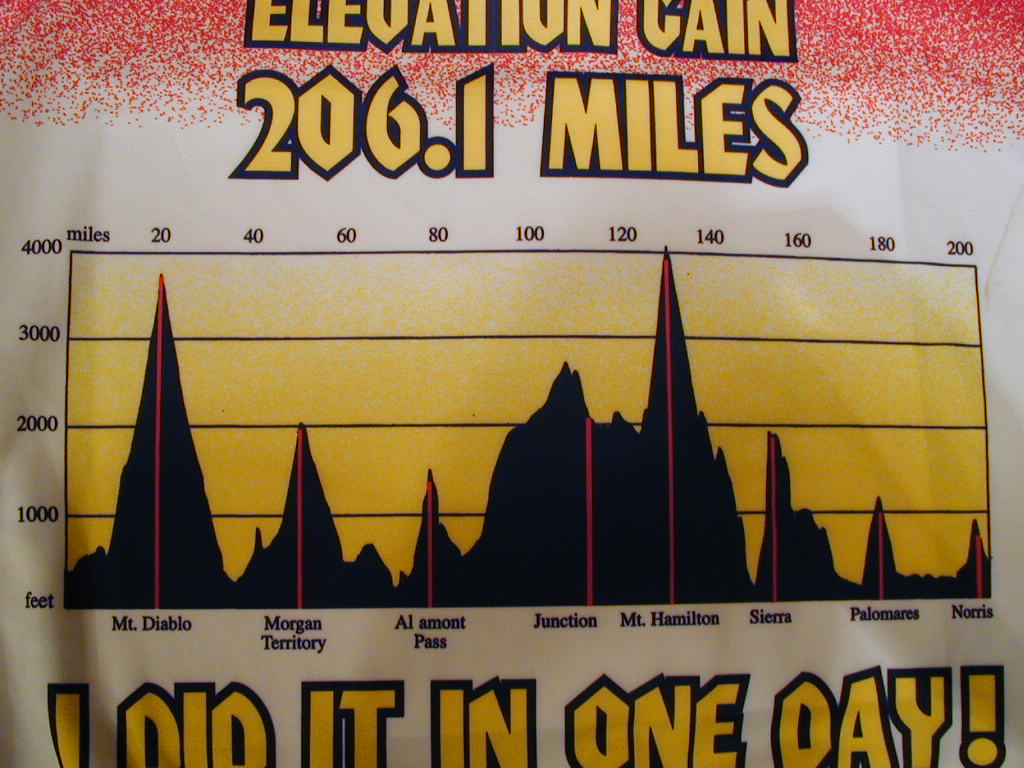
In this profile - Diablo and Hamilton are mountains, all the rest are hills. Of course others opinions will vary. I do label this ride steep at BJ because of the nature of the hills.
VeronicaLast edited by Veronica; 10-21-2008 at 03:55 AM.
-
10-21-2008, 04:20 AM #23
In-app purchases
- Join Date
- Sep 2007
- Location
- Uncanny Valley
- Posts
- 14,498
 April? 105-mile-a-day, nice and flat TOSRV is too much for May for those who don't winter in the South!
Girl, I never said you aren't strong!!! Don't ever think I said that! I don't doubt you could do CFC in your sleep.
Just don't dis our terrain or the riders here. Like my one riding buddy who did the Cinderella Century this year on a rented, poorly fitting mountain bike (the last bike she could get on short notice). And passed a whole lot of people while she was at it - she tells a story about how her knobby tires were making so much noise, people would yell "Car Back!" before she passed them. All of her training was here in the heartland, except for Mountain Mama, a little bit south of us - looks to be at least as many feet/mile as DMD, if half the distance - lots of people from our area did Mt. Mama, with no training on what you would consider "hills," and they finished it just fine (including one guy who broke his wrist early on and finished the ride anyway, but he's just nuts ).
Speed comes from what you put behind you. - Judi Ketteler
-
10-21-2008, 06:15 AM #24
"Ride lots!"
- Join Date
- Oct 2002
- Location
- San Francisco Bay Area
- Posts
- 9,324
Originally Posted by Veronica
Do people not notice Smiley Faces? I wasn't dissin anyone's terrain.
It's very different from where I typically ride. I'm always surprised at how high the reported average speeds are for these rides in the Midwest with the amount of climbing that they have. Since it's not the sort of stuff I ride, I'm trying to reconcile the numbers in my brain. So here's my current thinkin'...
On a climb like Diablo, I'll average between 7 and 8 miles an hour for ten miles. The descent doesn't allow me to make up much speed because it's so twisty. I'll average around twenty, maybe twenty-two if I'm lucky and feeling brave, on the descent.
In that link I posted there's only 6 miles of climbing on Saturday's route. I assume that same 7 - 8 mile an hour climbing pace, although because the climbs are shorter, a rider could climb faster. I also assume that the downhills are less twisty. I haven't been there, so I could be wrong But if that is true, a rider would get more speed on the downhills and maybe average closer to 30 mph. That would all lead to a much higher average speed than I get on a typical ride with 3,500 feet of climbing.
Like I said it's very different from where I ride.
Veronica
-
10-21-2008, 06:26 AM #25
"Ride lots!"
- Join Date
- Oct 2002
- Location
- San Francisco Bay Area
- Posts
- 9,324
Funny... I turned off my computer and walked away and was thinking about my post....
That link does only list 6 miles of climbing. But the profile says 3500 feet of climbing. So either that link does NOT list all the climbing or those 6 miles are WICKED steep.
Now think about this, if you hadn't factored in the 3,500 feet of climbing...
Six miles of climbing spread out in a in a 48 mile ride, with the longest climb being 1.3 miles, wouldn't you think the ride was kind of easy...
Maybe you would, maybe you wouldn't - all depends on who you are and where you're at. Bottom line - Ride Your Own Ride and have FUN!
Veronica
-
10-21-2008, 06:37 AM #26
Inner Geekette
- Join Date
- Aug 2003
- Location
- Bendemonium
- Posts
- 9,673
V, you know this: the roads as you travel farther east are built more and more vertically up the fall line and not the contour line as they do out here. Those river bluffs in the midwest are wicked steep and, as you know, it is hard to get into your climbing zone on "rollers" and those are long enough to actually force you into climbing mode as opposed to "momentum" mode.
This is what a friend has said about riding this stuff:
The "mere rollers" are constant, but after 100k of continuous, short 6-7% climb/descent cycles most people get a little rubbery in the leg.
Yeah, it is different than here in the wild, wild West.
Oakleaf, I don't live in Switzerland, but I've got a 23 mile climb nearly right from my door. The climb up Mt Diablo (on V's profile) rises the same elevation but in half the distance. I'd call both mountains. But I'm not arguing what is a hill or mountain, I'd just saying you can't "roll" over something the length of 3 and a half football fields in length. Your "mo" won't last that long. Though, wouldn't perpetual mo on a bike be wunnerful?Frends know gud humors when dey is hear it. ~ Da Crockydiles of ZZE.
-
10-21-2008, 08:02 AM #27
Team Embolism
- Join Date
- Jan 2006
- Location
- Marin County CA
- Posts
- 5,936
I'd agree on DMD Hamilton and diablo are the only mountains - but it that just a nomenclature issue?
It is Mt. Hamilton and mt. Diablo after all, so maybe it's just what we're used to.
I love the rollers, even the long ones. And I love our sustained climbs. I'm not sure how well I'd do in the eastern part with the steeper shorter stuff. It would be hard to get in a rhythm with that.
And from what I've seen and ridden of the Alps/Pyrenees, they're more like our Sierra roads with reasonable to high gradients; however, they pitch you up between the switchback instead of in the switchback like we do here, so you can often get more climbing overall. It was weird to have the actual switchback be the flat part where you can recover because it's so often not the case here.
Back to the original issue - and I'm not sure if anyone noted this yet, but weather can affect the barometric corrections. I spent a morning climbing the geysers and I and the other 5 people with Garmins all showed we were steadily descending. It was VERY odd, but the weather was changing dramatically from rainy/cold to warm.Sarah
When it's easy, ride hard; when it's hard, ride easy.
2011 Volagi Liscio
2010 Pegoretti Love #3 "Manovelo"
2011 Mercian Vincitore Special
2003 Eddy Merckx Team SC - stolen
2001 Colnago Ovalmaster Stars and Stripes
-
10-21-2008, 08:14 AM #28
back of the autobus
- Join Date
- Dec 2003
- Location
- Folsom CA
- Posts
- 5,667
When I start & end my ride at the same place, usually the total ascent/descent values (and the start/finish altitude) agree within a few percent, but once in a while they're very different. I assume that's because of weather changes over the course of my ride.
2009 Lynskey R230 Houseblend - Brooks Team Pro
2007 Rivendell Bleriot - Rivet Pearl
-
10-21-2008, 08:17 AM #29
droppin' off the back
- Join Date
- Aug 2008
- Location
- St. Louis, MO
- Posts
- 1,058
Thanks, Veronica. This was very educational for us newbies! (Going to search for "hill"
)
"Well-behaved women seldom make history." --Laurel Thatcher Ulrich
'09 Trek WSD 2.1 with a Brooks B-68 saddle
'11 Trek WSD Madone 5.2 with Brooks B-17
-
10-21-2008, 08:26 AM #30
Team Embolism
- Join Date
- Jan 2006
- Location
- Marin County CA
- Posts
- 5,936
I get that a LOT if I start from home. I concluded that it's because it is hard to get a good satellite lock from my house in all the trees, and even though it "says" it has the satellites I think it really takes some time for them to lock on. (My car Garmin won't even try to figure out where we are til we've got all the way down to town.) Originally Posted by jobob
Your reason makes a lot of sense as well. I'm sure there are a lot of variables.Sarah
When it's easy, ride hard; when it's hard, ride easy.
2011 Volagi Liscio
2010 Pegoretti Love #3 "Manovelo"
2011 Mercian Vincitore Special
2003 Eddy Merckx Team SC - stolen
2001 Colnago Ovalmaster Stars and Stripes


