Reply With Quote
According to weather.com, Arkansas is going to get hammered tonight with possible large tornados. Tuckervill, your region won't have the severe weather.
Welcome guest, is this your first visit? Click the "Create Account" button now to join.

Results 1 to 15 of 33
-
05-01-2010, 04:58 PM #1
 gravel grindess
- Join Date
- Jul 2007
- Location
- foothills of the Ozarks aka Tornado Alley
- Posts
- 4,193
 Southern TE'ers: tornado outbreak tonight
To disable ads, please log-in.
NATIONAL WEATHER SERVICE MEMPHIS TN
411 PM CDT SAT MAY 1 2010
ARZ008-009-017-018-026>028-035-036-048-049-058-MOZ113-115-
MSZ001>017-020>024-TNZ001>004-019>021-048>055-088>092-022315-
ALCORN-BENTON MS-CALHOUN-CARROLL-CHESTER-CHICKASAW-CLAY-COAHOMA-
CRAIGHEAD-CRITTENDEN-CROCKETT-CROSS-DESOTO-DECATUR-DUNKLIN-DYER-
FAYETTE-GIBSON-GREENE-HARDEMAN-HARDIN-HAYWOOD-HENDERSON-HENRY-
ITAWAMBA-LAFAYETTE-LAKE-LAUDERDALE-LAWRENCE-LEE AR-LEE MS-MADISON-
MARSHALL-MCNAIRY-MISSISSIPPI-MONROE-OBION-PANOLA-PEMISCOT-
PHILLIPS-POINSETT-PONTOTOC-PRENTISS-QUITMAN-RANDOLPH-SHELBY-
ST. FRANCIS-TALLAHATCHIE-TATE-TIPPAH-TIPTON-TISHOMINGO-TUNICA-
UNION-WEAKLEY-YALOBUSHA-
411 PM CDT SAT MAY 1 2010
THIS HAZARDOUS WEATHER OUTLOOK IS FOR PORTIONS OF EAST ARKANSAS...
THE MISSOURI BOOTHEEL...NORTH MISSISSIPPI...AND WEST TENNESSEE.
.DAY ONE...TONIGHT
FLASH FLOOD WATCH REMAINS IN EFFECT THROUGH SUNDAY FOR THE MID
SOUTH WITH AN ADDITIONAL THREE TO SIX INCHES OF RAINFALL
POSSSIBLE.
THERE IS A HIGH RISK OF SEVERE THUNDERSTORMS OVER THE MIDSOUTH...
OVER AREAS TO THE WEST OF A LINE FROM DYERSBURG TO BATESVILLE...
INCLUDING THE MEMPHIS METROPOLITAN AREA.
THERE IS A MODERATE RISK OF SEVERE THUNDERSTORMS FOR THE REST OF
THE MID SOUTH.
AN UPPER LEVEL WEATHER DISTURBANCE AND SURFACE COLD FRONT WILL
BRING ANOTHER ROUND OF SEVERE WEATHER AND VERY HEAVY RAINFALL TO
THE MID SOUTH THROUGH SUNDAY.
WIDESPREAD STORM TOTAL RAINFALL AMOUNTS OF FIVE TO TEN INCHES CAN
BE EXPECTED THROUGH SUNDAY ACROSS THE MID SOUTH WITH HIGHEST
AMOUNTS TO SEVENTEEN INCHES POSSIBLE.
THE NEXT ROUND OF SEVERE WEATHER WILL BRING DAMAGING WINDS AND THE
POTENTIAL FOR SIGNIFICANT TORNADOES. EXPECT AN UPSWING IN SEVERE
WEATHER THIS EVENING WHICH WILL CONTINUE OVERNIGHT.
.DAYS TWO THROUGH SEVEN...SUNDAY THROUGH SATURDAY
SEVERE THUNDERSTORMS AND FLASH FLOODING ARE LIKELY AGAIN DURING THE
DAY SUNDAY...MAINLY EAST OF THE MISSISSIPPI RIVER. THE TENNESSEE
RIVER VALLEY AND NORTHEAST MISSISSIPPI WILL LIKELY HAVE THE GREATEST
CHANCE OF SEVERE THUNDERSTORMS AND FLASH FLOODING.
And from Accuweather...
Another Major Tornado Outbreak to Hit South Tonight
May 1, 2010; 10:37 AM ETShare |
Just a week after a deadly tornado outbreak devastated the South, another one will unfold through tonight. As with last Saturday's outbreak, strong, long-track tornadoes will be possible during tonight's event.
Areas from northern Louisiana into central and eastern Arkansas, northern Mississippi, western Tennessee, far southeastern Missouri and far southwestern Kentucky that AccuWeather.com meteorologists are most concerned about.
Any tornadoes that form in this region could cause serious destruction if they hit a community. Cities such as Monroe, La., Oxford, Miss., Little Rock, Ark., and Memphis are included in this area of highest risk.
Ok folks, it's put on your helmet day. Check your stock of batteries, flashlights, and keep that weather alert radio handy. I wish you all luck as we collectively hunker down for the storm.
-
05-01-2010, 05:12 PM #2
gravel grindess
- Join Date
- Jul 2007
- Location
- foothills of the Ozarks aka Tornado Alley
- Posts
- 4,193
-
05-01-2010, 05:15 PM #3violetpurl Guest
Thanks Sundial! Not sure why I never thought of getting my helmet! I've been in the hall under a mattress once this evening - the dog was not thrilled. Luckily we dodged any serious damage. Hoping that we aren't up past midnight again tonight watching all the warnings and things pass thru quickly.
Hope everyone is safe.Last edited by violetpurl; 05-01-2010 at 05:18 PM.
-
05-01-2010, 05:20 PM #4
Registered User
- Join Date
- Sep 2008
- Posts
- 2,545
Everybody stay safe. I just got an email from my friend in Nashville, TN. They have flooding in addition to tornado warnings. Scary stuff!
-
05-01-2010, 06:24 PM #5
zippadee-doo-dah
- Join Date
- Apr 2007
- Location
- Limbo
- Posts
- 8,769
I have a root cellar to go to but no tornados here tonight.
2008 Trek FX 7.2/Terry Cite X
2009 Jamis Aurora/Brooks B-68
2010 Trek FX 7.6 WSD/stock bontrager
-
05-01-2010, 07:38 PM #6
Small world, big life!
- Join Date
- Apr 2006
- Posts
- 3,867
We have managed to avoid all the rounds of severe weather this week. I don't know how. I got out early to do some gardening, and about 9:30 it started to sprinkle and the sky darkened. I gathered up the tools and loaded up the tractor and put it all away, then ate a PBJ on the porch. By the time I was done, the sky was blue, my energy was back, and I ended up getting A LOT done. I shall list here for my pleasure:
*tilled and weeded the northeast flower bed.
*transplanted eonymus, vinca and some other thing into said flower bed.
*yelled at the dog for running through the transplants.
*dug a 40' long by 8" deep trench to make way for a brick edging along said flower bed (gotta get below that grass!).
*removed and cleaned enough salvaged bricks from the currently-being-dismantled 107-year-old smokehouse to line the trench.
*dug up 3 wheelbarrow loads of dirt from the bottom of the old mulch pile to fill in the trench
*poured 8, fifty# bags of sand into said trench.
*crushed up leftover mortar and crumbled brick to make more sand for said trench.
*leveled and tamped sand and laid bricks in trench.
*crushed up more leftover mortar and crumbled brick to wash into the gaps between bricks
*moved all the tools off the porch and tidied up.
*Pressure washed all the white trim and concrete around the front and back porches.
*ordered pizza.
*collapsed into bed.
I did have help with some of the brick work from my two youngest sons. Wouldn't have gotten this done if the weather hadn't changed!
Hope everyone is safe. I have lots of friends in Memphis, and both my husband and my son and his family are visiting Central Arkansas this weekend. They're safe, though.
Karen~~~~~~~~~~~~~~~~~~~~~~~~~~
insidious ungovernable cardboard
-
05-02-2010, 04:34 AM #7
Registered User
- Join Date
- Oct 2004
- Location
- Arlington, VA
- Posts
- 1,993
Karen, it's good that you had to yell at the dog only once! I bet you slept like a rock--that's a lot of hard work.
-
05-02-2010, 02:02 PM #8
gravel grindess
- Join Date
- Jul 2007
- Location
- foothills of the Ozarks aka Tornado Alley
- Posts
- 4,193
Karen-- good grief girl!! You were a busy bee! Glad the weather didn't interrupt your yard work. There's something cathartic about getting really dirty and tired from doing this kind of work. It gives you such a sense of satisfaction when it's completed.

Had several thunderstorms pass over during the night but nothing like the Friday night storm. Mr. Sundial had to get up and put the girls in the bathroom and shut the door so that they would calm down. I evidently slept through it because I awoke this morning and was surprised to see Kali and Niki's empty bed.
-
05-02-2010, 06:46 PM #9
Home of pea gravel
- Join Date
- Aug 2005
- Location
- Perth, Western Australia
- Posts
- 5,316
helmet
Why do you need to wear a safety helmet in your house during a storm??
-
05-03-2010, 07:29 AM #10
Ain't Love a Surprise?
- Join Date
- Nov 2005
- Location
- Between the Blue Ridge and the Chesapeake Bay
- Posts
- 5,203
Never been in a tornado, eh? Originally Posted by crazycanuck

Glad everyone's okay. I have family outside Nashville. They are wet.
-
05-03-2010, 07:01 PM #11
Home of pea gravel
- Join Date
- Aug 2005
- Location
- Perth, Western Australia
- Posts
- 5,316
no
No...
Keep safe!
-
05-04-2010, 12:07 PM #12
gravel grindess
- Join Date
- Jul 2007
- Location
- foothills of the Ozarks aka Tornado Alley
- Posts
- 4,193
Crazycanuck, comedian Ron White (Blue Collar Tour) made a joke about the Homeland Security threat level. To him there is no blue, green, yellow or red levels of threat. It's either "Get the d*** helmet!" or "Put on the d*** helmet!" In our case it was Put On The Helmet day. Originally Posted by crazycanuck


-
05-04-2010, 12:49 PM #13
thickly settled
- Join Date
- May 2008
- Location
- northern Virginia
- Posts
- 5,897
I have no root cellar. Just a 1BR condo on the second floor of a 3-story building. One night a couple years back they forecast possible tornadoes overnight. The only "interior room without windows" that I have is my bedroom closet, so I put my bike helmet, some pillows, my down quilt, several flashlights and a radio in there. Happily I had no need to duck and cover.
My other option would be to run screaming into the building hallway and hope one of my downstairs neighbors is home and lets me into their basement...
-
05-04-2010, 03:12 PM #14
gravel grindess
- Join Date
- Jul 2007
- Location
- foothills of the Ozarks aka Tornado Alley
- Posts
- 4,193
LOL! I do the same when it's really bad. My usual spot is sitting on the side of the bathtub hoping that I can actually fit in it with Kali's big butt taking up most of the space. She usually wins and I head for the closet with Niki. Originally Posted by ny biker
-
05-10-2010, 01:35 PM #15
gravel grindess
- Join Date
- Jul 2007
- Location
- foothills of the Ozarks aka Tornado Alley
- Posts
- 4,193
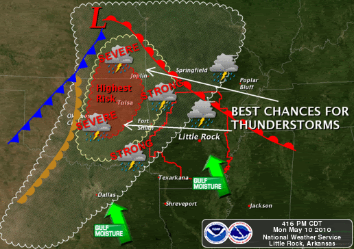
more severe weather for KS, OK and AR
Tornado Warning
SEVERE WEATHER STATEMENT
NATIONAL WEATHER SERVICE NORMAN OK
422 PM CDT MON MAY 10 2010
OKC047-071-103-102200-
/O.CON.KOUN.TO.W.0006.000000T0000Z-100510T2200Z/
GARFIELD OK-NOBLE OK-KAY OK-
422 PM CDT MON MAY 10 2010
...A TORNADO WARNING REMAINS IN EFFECT UNTIL 500 PM CDT FOR SOUTHERN
KAY...NORTHERN NOBLE AND EASTERN GARFIELD COUNTIES...
AT 422 PM CDT...NATIONAL WEATHER SERVICE RADAR DETECTED A SEVERE
THUNDERSTORM CAPABLE OF PRODUCING A TORNADO 4 MILES SOUTHWEST OF
GARBER...MOVING NORTHEAST AT 55 MPH.
* LOCATIONS IN THE WARNING INCLUDE BILLINGS...CERES...GARBER...
MARLAND...RED ROCK AND SOONER LAKE.
THIS INCLUDES INTERSTATE 35 BETWEEN MILE MARKERS 190 AND 210.
PRECAUTIONARY/PREPAREDNESS ACTIONS...
A TORNADO MAY FORM AT ANYTIME. TAKE COVER NOW. ABANDON MOBILE HOMES
AND VEHICLES. IF POSSIBLE... MOVE TO A BASEMENT OR STORM SHELTER.
OTHERWISE... MOVE TO AN INTERIOR ROOM OR HALLWAY ON THE LOWEST FLOOR.
STAY AWAY FROM WINDOWS.
HAZARDOUS WEATHER OUTLOOK
NATIONAL WEATHER SERVICE LITTLE ROCK AR
500 AM CDT MON MAY 10 2010
ARZ003>007-012>016-021>025-030>034-037>047-052>057-062>069-111000-
ARKANSAS-BAXTER-BOONE-BRADLEY-CALHOUN-CLARK-CLEBURNE-CLEVELAND-
CONWAY-DALLAS-DESHA-DREW-FAULKNER-FULTON-GARLAND-GRANT-HOT SPRING-
INDEPENDENCE-IZARD-JACKSON-JEFFERSON-JOHNSON-LINCOLN-LOGAN-LONOKE-
MARION-MONROE-MONTGOMERY-NEWTON-OUACHITA-PERRY-PIKE-POLK-POPE-
PRAIRIE-PULASKI-SALINE-SCOTT-SEARCY-SHARP-STONE-VAN BUREN-WHITE-
WOODRUFF-YELL-
500 AM CDT MON MAY 10 2010
THIS HAZARDOUS WEATHER OUTLOOK IS FOR A LARGE PART OF ARKANSAS.
.DAY ONE...TODAY AND TONIGHT
SHOWERS AND ISOLATED THUNDERSTORMS IN THE NORTHEAST HALF OF ARKANSAS
EARLY THIS MORNING WILL EXIT TO THE NORTHEAST BY THIS AFTERNOON.
PRECIPITATION WILL BE FOLLOWED BY WARMER AIR AS A WARM FRONT LIFTS
INTO THE STATE FROM THE GULF COAST.
MEANWHILE...A STRONG STORM SYSTEM WILL TRACK FROM COLORADO INTO
NORTHWEST MISSOURI THROUGH THIS EVENING. THE SYSTEM WILL PRODUCE
BREEZY EAST TO SOUTHEAST WINDS ACROSS THE REGION.
THE SYSTEM WILL DRAG A COLD FRONT TOWARD ARKANSAS...WITH
SCATTERED THUNDERSTORMS DEVELOPING ALONG THE FRONT. SOME OF THESE
STORMS COULD BUILD INTO THE NORTHWEST COUNTIES TONIGHT...AND COULD
BRING SEVERE WEATHER. HOWEVER...SEVERE STORMS WILL BE MOST LIKELY IN
SOUTHEAST KANSAS AND EASTERN OKLAHOMA.
.DAYS TWO THROUGH SEVEN...TUESDAY THROUGH SUNDAY
THE FRONT TO THE WEST WILL STALL AS HIGH PRESSURE STRENGTHENS OVER
THE SOUTHEAST UNITED STATES. THE HIGH WILL KEEP UNSETTLED WEATHER
MAINLY TO THE NORTH AND WEST OF THE STATE THROUGH WEDNESDAY...WITH
WARM CONDITIONS ACROSS THE REGION.
LATE IN THE WEEK...IT APPEARS THE FRONT WILL MOVE INTO ARKANSAS.
HIGH PRESSURE WILL SLOW THE PROGRESSION OF THE FRONT...RESULTING IN
SEVERAL DAYS OF CLOUDS AND PRECIPITATION.
THERE WILL BE PLENTY OF MOISTURE THURSDAY INTO THE WEEKEND.
PRECIPITATION WILL FOCUS AROUND THE SLOW MOVING FRONT...AND COULD
BECOME HEAVY TO EXCESSIVE...ESPECIALLY IN THE NORTHWEST HALF OF
ARKANSAS.