


 Reply With Quote
Pretty steep hill. I grew up in upstate NY then moved to CO. I have biked far stepper hill in NY then I have ever found out here in CO. Keep up the great work, just think "power"
Welcome guest, is this your first visit? Click the "Create Account" button now to join.

Results 1 to 15 of 44
Thread: What Does 25% Grade Look Like?
-
07-15-2007, 06:24 PM #1
 f/k/a Mr. S.
- Join Date
- Dec 2006
- Location
- Blessed to be all over the place!
- Posts
- 3,433
What Does 25% Grade Look Like?
To disable ads, please log-in.
You might be surprised. This is near the Ohio River in our small suburb...Its about 320 feet from the stop sign to the top of the hill; my Garmon measured it at 25% grade - much to my surprise.
I have done it twice, but I'm using the first and second gear (on a triple). I tried to start it in 5th gear and couldn't get halfway...unable to shift down at such slow speed.
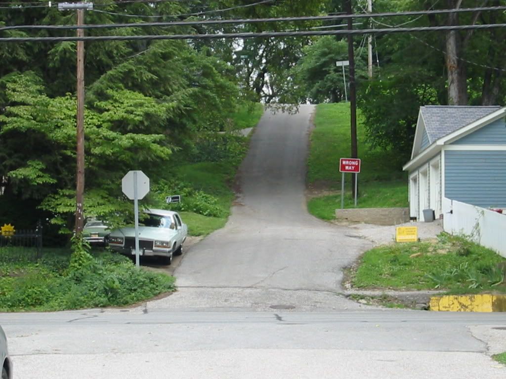
And, I never knew I was going the "Wrong Way" until I looked at this picture. For obvious reasons, it doesn't get much traffic...If you don't grow where you're planted, you'll never BLOOM - Will Rogers
-
07-15-2007, 06:29 PM #2
Registered User
- Join Date
- Jun 2005
- Location
- Colorado
- Posts
- 1,627
-
07-15-2007, 07:08 PM #3
I like my bike
- Join Date
- Mar 2007
- Location
- Sierra Foothills, CA
- Posts
- 800
Mr. Silver - I'm so glad you posted this! It's ironic...just today I was pondering grade percentages and wishing I could figure out how steep some of the hills are around here. I don't have GPS or anything else for measuring. I know what a 3% grade is like because the local bike path runs up an old 3% railroad grade. Now I also know what 25% looks like. Hmmm, does anyone else have pictures of a 5%, 8%, 10%, 12%, 15%, etc.? Just kidding
")
Good job making it up that hill...I would only attempt it in my super granny gear and even then, it looks like a challenge!
-
07-15-2007, 07:11 PM #4
Registered User
- Join Date
- Dec 2005
- Location
- WA State
- Posts
- 4,364
lol - if you ask me after a certain steepness they all "look" the same. I've tried to use some of those online route mapping sites, but there's just too much margin of error. Originally Posted by sara
 "Sharing the road means getting along, not getting ahead" - 1994 Washington State Driver's Guide
visit my flickr stream http://flic.kr/ps/MMu5N
-
07-15-2007, 07:22 PM #5
I like bikes
- Join Date
- Apr 2006
- Location
- Seattle
- Posts
- 8,548
Eden, let's go out with a bike computer and an altimeter; we can figure it out!
-
07-15-2007, 07:22 PM #6
I heart my bike
- Join Date
- Apr 2006
- Location
- where the wind comes sweeping down the plain
- Posts
- 5,251
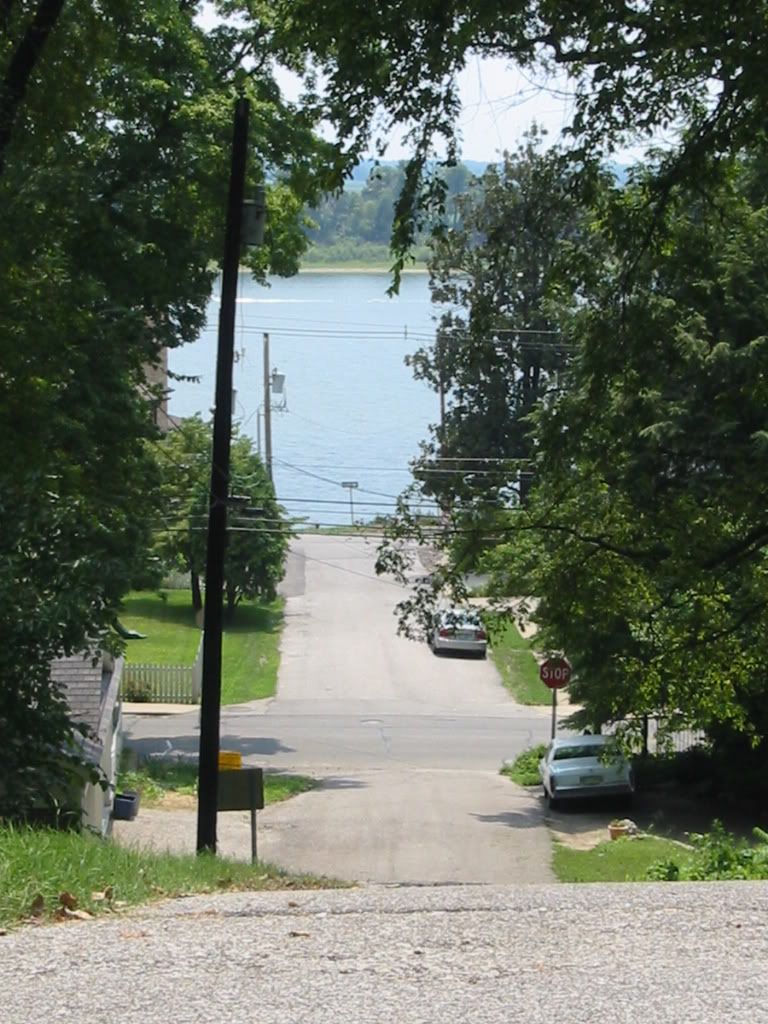
Yowzers that's steep! Good thing you've been going up the wrong way, because if you were going down I don't think you could stop in time- you'd be swimming in the lake up ahead.
 Check out my running blog: www.turtlepacing.blogspot.com
Cervelo P2C (tri bike)
Bianchi Eros (commuter/touring road bike)
1983 Motobecane mixte (commuter/errand bike)
Cannondale F5 mountain bike
-
07-15-2007, 07:24 PM #7
Registered User
- Join Date
- Dec 2005
- Location
- WA State
- Posts
- 4,364
It would be easy with that info - rise over run! shucks tho - I don't have any fancy gadgets like that - spent all my money on the fancy bike.... Originally Posted by mimitabby
"Sharing the road means getting along, not getting ahead" - 1994 Washington State Driver's Guide
visit my flickr stream http://flic.kr/ps/MMu5N
-
07-15-2007, 07:38 PM #8
I like bikes
- Join Date
- Apr 2006
- Location
- Seattle
- Posts
- 8,548
oh.. I don't either! But Raleighdon has enough of that equipment to drive his bike out into space.
-
07-16-2007, 03:19 AM #9
Registered User
- Join Date
- May 2007
- Posts
- 317
US geological survey topo maps will let you get an approximate grade for large hills. I've cross checked them on hills I know have a posted grade, and it's usually pretty close (+/- 1% or better). The only depressing part about checking them was discovering that my nemesis hill is a piddling 5% grade on the steepest incline. *shakes her fist at Wisconsin for being so flat*
-
07-16-2007, 04:08 AM #10
Slow and Steady
- Join Date
- Oct 2006
- Posts
- 1,057
Torrilin, Torrilin, Torrilin...what am I going to do to convince you that not all of Wisconsin is flat!?!?!?!?!? Where are you located? Perhaps I can help you find a real hill?
Even with the fancy gadgets, getting a good measure on a hill is hard. A good lock on my GPS and all measurements are still +/- 15m. I've gotten pretty good at doing running averages when I'm going up hills, ignoring those first glimpses of 10-12% unless I see a lot in that range. I have a hill that I can see several spikes into th high teens, but it averages out to only 12%.
In Italy we saw some really steep grades...going into one of the hill towns was a 25% grade. Quite a bit longer than your road, Mr. Silver, but I will admit I didn't make it up the hill...oh, it wasn't that I ran out of oomph...oh, no...it was because I was moving so slowly the horse parade caught up and I had to pull off, of course Seriously, there was a horse parade, but, ok, I really wasn't going any farther. 25% is really steep--I'm impressed you can get up that hill.
Oh, and I agree with Eden--all inclines start to look the same. I have some 4% grades nearby that look almost flat, but in Italy, after climbing for an hour, I was convinced the road was going downhill, but I looked at the GPS and it said a steady 4%. It is just a matter of perspective.
-
07-16-2007, 04:23 AM #11
Registered User
- Join Date
- May 2007
- Posts
- 317
I'm in Madison. And I know it's not *all* flat, but I'm used to the mountains around LA and central PA hills. So lots of things that a sane person would say is hilly I look at and go "that's flat".
Never claimed to be sane tho
-
07-16-2007, 04:53 AM #12
listen to the bees
- Join Date
- Jul 2006
- Location
- Riding my Luna & Rivendell in the Hudson Valley, NY
- Posts
- 8,411
I live in rural upstate NY and we have nothing but rolling hills around us in every direction, and some of them are killers. My riding average is usually only 10 mph partly because of the hills. Originally Posted by solobiker
I have tried to take pictures of some of the hills but through the camera lens they don't look nearly as steep as they are in real vision for some weird reason. In the phoots they look dinky and then I put the camera down and they looks monstrous again! Sort of like how a photo of a sunset never looks nearly as breathtaking as the real thing.
Lisa
My mountain dulcimer network...FOTMD.com...and my mountain dulcimer blog
My personal blog:My blog
^^^^^^^^^^^^^^^^^^^^^^^^^^^^^^^^^^^^^^^^^^^^^^^^^^^^^^^^^^^^^^^^^^^^
-
07-16-2007, 05:10 AM #13
Can't never could!
- Join Date
- Apr 2006
- Location
- somewhere between the Red & Rio Grande
- Posts
- 5,297
Lisa- We have a lot rollers mixed with an equal amount of steep hills. I don't know of one ride from our house that could be considered flat! I wonder how bad the grades are? A lot of them look as steep as Mr. Silver's hill.
The other thing that makes some of the not so intimidating ones bad is the quality of road. They may be rough county roads, turn or have banking. It sure does make you strong for a flat ride.
Amanda
2011 Specialized Epic Comp 29er | Specialized Phenom | "Marie Laveau"
2007 Cannondale Synapse Carbon Road | Selle Italia Lady Gel Flow | "Miranda"
You don't have to be great to get started, but you do have to get started to be great. -Lee J. Colan
-
07-16-2007, 05:34 AM #14
Slow and Steady
- Join Date
- Oct 2006
- Posts
- 1,057
Originally Posted by Torrilin
Sure...we ain't got mountains, but I guess I prefer rollers for training--consider it speedwork for those long mountain rides you really want to do when you go back to visit LA and PA!
If you're in Madison, you're just a hop, skip, and a car transport to Bluemounds. The Horrible Hilly people keep their cue sheet on line--http://www.horriblyhilly.com/course.html Never long by mountain standards, but many steep hils. That route was actually plotted to maximize incline. A little west still has some steep ones... Try http://www.dairylanddare.com/ for another cue sheet.
Of course, I'm rather smitten with that area of the state--rolling hills, gorgeous land, relatively friendly vehicles. Sigh..but I'm a long way away.
But count your blessings--you could be located in the Stevens Point area--the sandy flat lands of the former glacial Lake Wisconsion. I think Florida has more hills than they do.
-
07-16-2007, 06:03 AM #15
Registered User
- Join Date
- Jun 2005
- Posts
- 268
Wow, that looks painful. The only blessing is that it is short compared to what it could be. Imagine trying to climb that beast for another 100ft. I don't think I would make it.


