


 Reply With Quote
The elevation profile works now.Originally Posted by Veronica

Welcome guest, is this your first visit? Click the "Create Account" button now to join.

Results 46 to 60 of 81
Thread: Elevation info center
-
04-10-2007, 07:29 AM #46
 Team Embolism
- Join Date
- Jan 2006
- Location
- Marin County CA
- Posts
- 5,936
To disable ads, please log-in.
Wow - that's very cool, V! I am impressed!
Sarah
When it's easy, ride hard; when it's hard, ride easy.
2011 Volagi Liscio
2010 Pegoretti Love #3 "Manovelo"
2011 Mercian Vincitore Special
2003 Eddy Merckx Team SC - stolen
2001 Colnago Ovalmaster Stars and Stripes
-
04-10-2007, 07:33 AM #47
Inner Geekette
- Join Date
- Aug 2003
- Location
- Bendemonium
- Posts
- 9,673
Frends know gud humors when dey is hear it. ~ Da Crockydiles of ZZE.
-
04-10-2007, 07:35 AM #48
Inner Geekette
- Join Date
- Aug 2003
- Location
- Bendemonium
- Posts
- 9,673
MP, I uploaded the gpx file from your Atlas/Veeder ride to bikely. Worked slick except there were so many waypoints that trying to edit was a huge hassle.
If I'm looking for entertainment I suppose I could download V's dbc file, re-load (as a copy), edit it (since it has fewer waypoints) and then you could be load to your Garmin.Frends know gud humors when dey is hear it. ~ Da Crockydiles of ZZE.
-
04-10-2007, 07:38 AM #49
Team Embolism
- Join Date
- Jan 2006
- Location
- Marin County CA
- Posts
- 5,936
Yeah, problem is I don't want to try to look at the Garmin for directions because it's going to be hard to see when I need it (in the dark). There's a light, but I don't want to burn the extra battery if I don't have to.
Just going over and over the parts of the route that I am not familiar with in these different routing thingies is going to be very helpful. For the 600, I plotted the parts I didn't know in Topo and then "rode" the whole route in Google Earth. It just really helps to be familiar with the route. I also hope to be riding with Jim during the tricky night parts and he's done the ride before.Sarah
When it's easy, ride hard; when it's hard, ride easy.
2011 Volagi Liscio
2010 Pegoretti Love #3 "Manovelo"
2011 Mercian Vincitore Special
2003 Eddy Merckx Team SC - stolen
2001 Colnago Ovalmaster Stars and Stripes
-
04-10-2007, 07:40 AM #50
back of the autobus
- Join Date
- Dec 2003
- Location
- Folsom CA
- Posts
- 5,667
Originally Posted by Veronica
Ah, you have an elevation profile now. Total climbing doesn't look bad, 4500-4700 feet over 200K. Those hills between miles 50-70, are those the ones on 128 between Moskowite and Pleasants Valley Road?
Geeze, no Cobb Mtn, whatta buncha wusses ....
2009 Lynskey R230 Houseblend - Brooks Team Pro
2007 Rivendell Bleriot - Rivet Pearl
-
04-10-2007, 07:43 AM #51
Team Embolism
- Join Date
- Jan 2006
- Location
- Marin County CA
- Posts
- 5,936
So - what are you waiting for?? Sign up!!! Originally Posted by jobob
 Sarah
Sarah
When it's easy, ride hard; when it's hard, ride easy.
2011 Volagi Liscio
2010 Pegoretti Love #3 "Manovelo"
2011 Mercian Vincitore Special
2003 Eddy Merckx Team SC - stolen
2001 Colnago Ovalmaster Stars and Stripes
-
04-10-2007, 07:56 AM #52
back of the autobus
- Join Date
- Dec 2003
- Location
- Folsom CA
- Posts
- 5,667
LOL, I knew that was coming !!
Sorry love, I'm just not ready yet ... psychologically, anyhow.
2009 Lynskey R230 Houseblend - Brooks Team Pro
2007 Rivendell Bleriot - Rivet Pearl
-
04-10-2007, 08:01 AM #53
"Ride lots!"
- Join Date
- Oct 2002
- Location
- San Francisco Bay Area
- Posts
- 9,324
You could ride the end with us. I'm hooking up with MP at checkpoint 4. So only120 miles.
I'm bringing our GPS. It's the Calistoga section and Vacaville that I'm worried about getting lost in. The rest is pretty straightforward.
V.
-
04-10-2007, 08:12 AM #54
Team Embolism
- Join Date
- Jan 2006
- Location
- Marin County CA
- Posts
- 5,936
Jim's saying maybe 17 hours total. I am not so sure, but our paces were really compatible in the 300, and he's done this before. Anyway, I expect 7 - 8 hours to the turn around at this point. So, what does that make it, 1 - 2 pm?
Sarah
When it's easy, ride hard; when it's hard, ride easy.
2011 Volagi Liscio
2010 Pegoretti Love #3 "Manovelo"
2011 Mercian Vincitore Special
2003 Eddy Merckx Team SC - stolen
2001 Colnago Ovalmaster Stars and Stripes
-
04-10-2007, 08:30 AM #55
back of the autobus
- Join Date
- Dec 2003
- Location
- Folsom CA
- Posts
- 5,667
Spazz, you want profiles? okey dokey
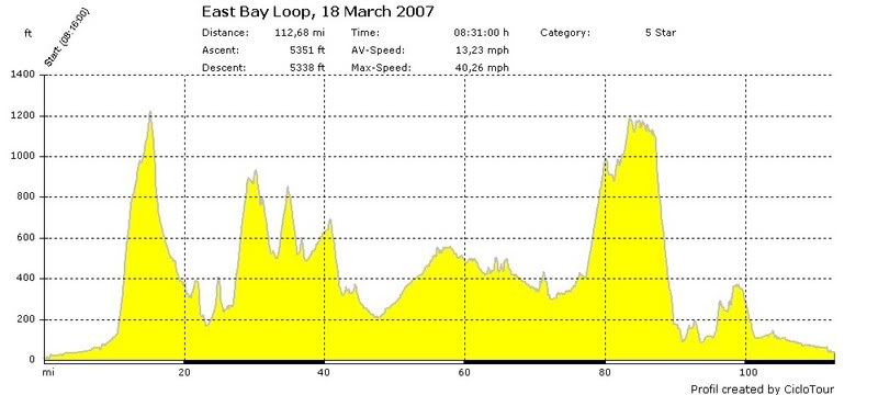
Here's my full East Bay loop, the day I rode it with V.
The first hill is Palomares, the next one is Redwood Road, followed by Pinehurst, then Canyon. Spazz, I met up with you and Trek on Sunday at the top of Canyon around the mile 40 point. On Sunday I stopped at mile 72, just before the kickup to Calveras Road.
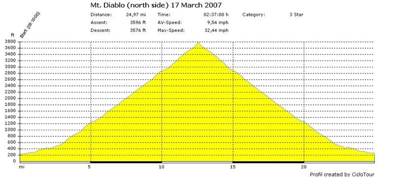
And here's Mt. Diablo, north side, starting from Arbolado Park in Walnut Creek.
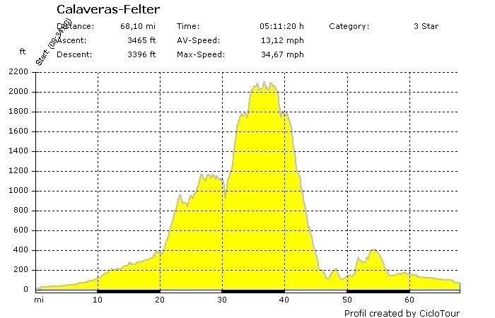
And here's a ride a bunch of us did from my home, over Calaveras, up Felter Road to the top of Sierra Rd., then back down Felter.
2009 Lynskey R230 Houseblend - Brooks Team Pro
2007 Rivendell Bleriot - Rivet Pearl
-
04-10-2007, 08:46 AM #56
Ask me about my book :)
- Join Date
- Aug 2004
- Location
- North Texas
- Posts
- 1,565
 Now THAT's what I'm talkin' about
Thanks jobob!
Has anybody climbed Pinehurst? Or does the above profile mean YOU did jobob (you are a goddess)?
Going down it was a blast, and I kept repeating to myself "I don't wanna go up this - I don't wanna go up this!" as I squeezed the life out of my brakes.
spazzno regrets!
My ride: 2003 Specialized Allez Comp - zebra (men's 52cm), Speedplay X5 pedals, Koobi Au Enduro saddle
Spazzdog Ink Gallery
http://www.printroom.com/pro/gratcliff
-
04-10-2007, 08:56 AM #57
Team Embolism
- Join Date
- Jan 2006
- Location
- Marin County CA
- Posts
- 5,936
that is SO cool. I need to learn how to make those profiles come out like that, like a picture almost.
diablo looks like a perfect egyptian pyramid.Sarah
When it's easy, ride hard; when it's hard, ride easy.
2011 Volagi Liscio
2010 Pegoretti Love #3 "Manovelo"
2011 Mercian Vincitore Special
2003 Eddy Merckx Team SC - stolen
2001 Colnago Ovalmaster Stars and Stripes
-
04-10-2007, 09:00 AM #58
Inner Geekette
- Join Date
- Aug 2003
- Location
- Bendemonium
- Posts
- 9,673
Isn't the Calistoga section just like the Santa Rosa 200K? The loop in Geyserville is different but it will be daylight. Originally Posted by Veronica
For Vacaville -
--Come down Cardiac and hang a right at Pardehsa's Store (the 3-way to Lake Solano) and you know this intersection
--Go south for several miles up a false flat with a few rollers. The top will be Cantelow Rd (1st turn to the left).
-- Stay straight and continue several miles on a long slow downhill past the 2nd road to your left.
--3rd rd on your left is Foothill and the biggest intersection of the 3.
--This is the key: once you swoop around at the beginning of Foothill, you will essentially begin a series of turns that always take you east or north. The one exception is the I-80 overpass at Sparling and Pedrick which you know from the Fall 200k.
--Once you're over 1-80, it's the same return route. Stay on Tremont until you run into the T and turn north. Last leg take you right to the finish.Frends know gud humors when dey is hear it. ~ Da Crockydiles of ZZE.
-
04-10-2007, 09:08 AM #59
Team Embolism
- Join Date
- Jan 2006
- Location
- Marin County CA
- Posts
- 5,936
I think there's a control in calistoga. maybe we should scootch this discussion back over to the long distance thread...
Sarah
When it's easy, ride hard; when it's hard, ride easy.
2011 Volagi Liscio
2010 Pegoretti Love #3 "Manovelo"
2011 Mercian Vincitore Special
2003 Eddy Merckx Team SC - stolen
2001 Colnago Ovalmaster Stars and Stripes
-
04-10-2007, 09:30 AM #60
back of the autobus
- Join Date
- Dec 2003
- Location
- Folsom CA
- Posts
- 5,667
Those are all downloaded from my cycle computer, a Ciclosport CM436(??)M (I'm at work right now so I don't remember the exact number, not that it matters 'cuz I think it's been discontinued), so yes indeedy I did all those rides. Originally Posted by spazzdog

Pinehurst is the middle bump in the group of 3 hills between miles 30-40. Except I did the part of Pinehurst south of Canyon Rd, whereas you rode the part north of Canyon. So you'll just have to take me along next time you go.
MP, you have a HAC4, right? I can explain to you offline how I copied these profies as jpegs; since they're both made by Ciclosport I imagine the software might be similar.
2009 Lynskey R230 Houseblend - Brooks Team Pro
2007 Rivendell Bleriot - Rivet Pearl


